ATLAS of SAGINAW COUNTY
|
County Atlas
Three Saginaw County Atlases are reproduced here. Following each is an index listing all the names that appeared in the atlas. Original content lists appear near the front of each of the books, and land plat maps give aid to land researchers and genealogists. The transcribing, compiling, alphabetizing and typing of the 28,000 names from the three atlases has been the task of many members of this society. Thanks are here expressed for the many hours of selfless labor, which have made these rare books available again to the public with the convenience of the indexes. The Indexing Committee Old Atlases of
| |||||||
| saginaw_county_atlas_-1877.pdf |
| saginaw_county_atlas-1896.pdf |
| saginaw_county_atlas-_1916.pdf |
List of Plat maps
that are available at the Hoyt Library
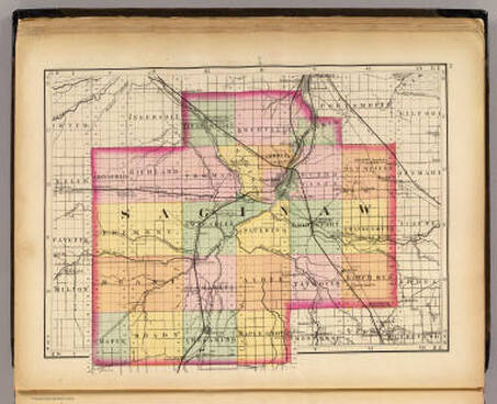
Current Saginaw County Map
Click on map above to view
MORE ON PLAT MAPS
PLEASE NOTE: Hoyt Library will always take donations of old plat maps for their collection.
What are Plat maps?
Its a map, drawn to scale, showing the divisions of a piece of land. Further refinement often splits blocks into individual lots, usually for the purpose of selling the described lots; this has become known as subdivision. A plat directory is a land ownership map book. Each book shows every parcel of land within a specific county. Parcels of land that are 5 acres or more are labeled with the owner's name. So with this information you can go look up family names from property in the area you are searching. There is an index in the back to help you find the names.
T-R-S, What does that stand for?
T - Township, R- Range, S - Section. Please see the "TUTORIAL" page for a further explanation.
Why some parcels don't show an owner's name
In some books, any parcel with less than 5 acres is simply too small to label. If a large parcel of land has no owner listed, it means that the information was not available at the time of publication.
When was my book published?
Look for the COPYRIGHT DATE on the bottom of the front cover.
Locating Features Using the
United States Public Land Survey System
(Township and Range) and Google EarthTM
Section: The basic unit of the system, a square piece of land one mile by one mile containing 640 acres.
Township: 36 sections arranged in a 6 by 6 square, measuring 6 miles by 6 miles. Sections are numbered beginning with the northeast-most section (#1), proceeding west to 6, then south along the west edge of the township and to the east (#36 is in the SE corner).
Range: Assigned to a township by measuring east or west of a Principal Meridian
Range Lines: The north to south lines which mark township boundaries.
Township Lines: The east to west lines which mark township boundaries.
Principal Meridian: The reference/beginning point for measuring east or west ranges. Map of meridians & base lines from the BLM web server
Base line: Reference or beginning point for measuring north or south townships.